Taiwanese-born scientist dives to Earth’s deepest part

CHALLENGER DEEP: Lin Ying-Tsong was invited by Caladan Oceanic founder Victor Vescovo to join him on a 10-hour long trip in the company’s submersible

By Lin Chia-nan

Taiwanese-American Lin Ying-Tsong (林穎聰) last month became the first person from Asia and the 12th in human history to dive into the deepest part on Earth, the Challenger Deep in the Mariana Trench.

Lin, 45, an expert in deep sea acoustics with the Woods Hole Oceanographic Institution (WHOI) in Massachusetts, joined US adventurer and Caladan Oceanic founder Victor Vescovo, 54, on June 22 in a descent to the central pool of the Challenger Deep, the deepest point of the trench, which lies at a depth of more than 10,900m.

The pair made the descent in a submersible named Limiting Factor, a US$37 million two-seater commissioned by Vescovo from Triton Submarines.

Unlike astronauts who have to wear a spacesuit, they did not experience significant changes of atmosphere, temperature or humidity in the submersible, Lin said in a telephone interview with the Taipei Times on Tuesday last week, after he returned to Massachusetts.

Inside the submersible’s capsule the pressure was kept at one standard atmospheric pressure, while the temperature dropped from about 28 ° C to 20 ° C during the dive and climb, he said, adding that the dive and the return climb took a total of 10 hours.

There are three windows in the capsule, and when looking out from the window beneath their feet, he felt as if he was doing a “seawalk,” Lin said.

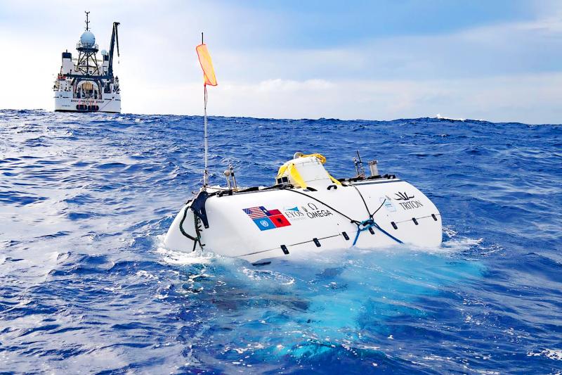
Photo courtesy of Caladan Oceanic

The ocean bottom appeared to be an otherworldly desert of deadly gray, where only limited species, such as amphipods, can survive the extreme conditions, he said.

When ascending to the surface, he saw, from the depth of nearly 300m, sunlight gradually extend into a carpet of radiance that brought all colors back, he said, describing the scene as a “sunrise in ocean.”

Maintaining the balance of oxygen and carbon dioxide in the capsule was a matter of life and death, so Vescovo, who was piloting the craft, had to regularly check that oxygen was evenly released, Lin said.

The submersible was equipped with an oxygen reserve sufficient to last two passengers for four days.

Lin’s descent was part of the Caladan Oceanic’s Ring of Fire expedition that began last month, which also included dives by former NASA astronaut Kathy Sullivan — the first US woman to complete a spacewalk — and Kelly Walsh — the son of Don Walsh, the first person to descend to the Challenger Deep, in 1960.

Asked how he got involved in the team, Lin said he received an e-mail invitation from Vescovo, whom he had not met before, in late May after he returned from a cruise to measure underwater acoustics for an offshore wind farm project.

While Vescovo reportedly has opened some dive slots for paying customers, Lin said his descent was sponsored by Vescovo.

“I must have done something noble in my former life, such as saving millions of lives, to have the opportunity to join the team,” he said, still sounding excited by his adventure.

“Because he is an expert in deep ocean acoustics, measurement, and tracking, Dr Lin’s involvement in the expedition was important in advancing further exploration and understanding of how sound waves propagate in the deepest parts of the ocean,” Caladan Oceanic said in a press release.

“I was also happy to make the descent with the first person from Taiwan in a first for that country — and continent — since I strongly support the special US-Taiwan relationship,” Vescovo, a former US Navy commander, said in the statement.

Using the submersible and the company’s support ship the Pressure Drop, Lin conducted a series of acoustics experiments in the week of his dive, including surveying ambient sound and acoustic signals with a hydrophone recorder provided by the US National Oceanic and Atmospheric Administration.

The surveys aim to advance understanding about how sounds propagate and refract in different ocean layers and how the derived coefficients can be applied to estimate the geological components of seabed, Lin said.

He said he had been impressed by how quiet the ocean could be.

The deep sea’s ambient sound only measured 55 decibels when there was no container ship passing by, as the COVID-19 pandemic has reduced ship traffic, he said.

Lin also admired the teamwork of the expedition team, which has concrete scientific goals, including mapping the sea floors and collecting biological and geological samples at the bottom of the Challenger Deep.

“I feel home here [the expedition] like at WHOI, because we are all team players, no individuals, no pointing fingers,” Lin wrote on Facebook on June 27.

Lin obtained his master’s and doctoral degrees from National Taiwan University’s engineering science and ocean engineering department, and then went to Woods Hole to conduct postdoc research, but stayed on after finishing his research project and is now a tenured associate scientist at the institute, where his work has won him several awards.

He said that he has benefited from decades-long Taiwan-US collaboration in ocean research and now he serves as a bridge to sustain the ties from his vantage point at one of the world’s top ocean research institutions.

Lin said that Taiwan’s government should lend more support to ocean sciences and promote public education about the oceans, while scientists from different backgrounds should strengthen their collaborative efforts.

“Taiwan is a maritime country” should be more than just a slogan, he said.

A strong nation is bolstered by its sea power, which could be enhanced by boosting ocean research capacity, he added.

Source:https://www.taipeitimes.com/News/taiwan/archives/2020/07/10/2003739683

Distinguishing floating plastics from space

A pioneering technique to detect aggregated patches of plastics floating on the sea surface has been published in Scientific Reports.

Led by scientists at Plymouth Marine Laboratory, Earth observation scientists analysed data from the European Space Agency’s Sentinel-2 satellites to develop this new approach, which demonstrates for the first time that aggregated patches of plastics floating in coastal waters can be detected by satellites.

Using this method, aggregations of plastic particles larger than 5mm (macroplastics) were also distinguishable from naturally occurring floating materials, such as seaweed, driftwood and foam, with an average accuracy of 86% across four case study sites.

This technical challenge, primarily funded by the Natural Environment Research Council’s ACCORD research programme, is the first step towards developing an operational method of detecting floating plastic patches in waters all over the world.

The team ran high-resolution, multi-spectral optical satellite data of coastal waters through an algorithm tuned to highlighting objects floating on the ocean surface, creating the Floating Debris Index (FDI) for the Sentinel-2 Multi-spectral Instrument.

The next stage was to identify floating plastics. Thanks to a collaboration with the University of the Aegean, who shared information on deployed plastic targets for their new study into plastic litter, the team was able to know exactly what Sentinel-2 was ‘seeing’ through the FDI and, therefore, able to build an optical signature for floating plastics. These known plastic detections were supplemented with validated plastics data detected after severe flooding in Durban, South Africa. Once the plastic signatures were established, the team then began the same process for natural debris, such as driftwood, seaweed and seafoam, which are likely to be mixed in with the plastic patches.

With the algorithm development and validation complete, the team began searching for plastics ‘in the wild’. Based on published studies and social media posts, they detected aggregations in two developed countries – Canada (San Juan Islands) and Scotland – and two developing countries – Ghana (Accra) and Vietnam (Da Nang).

Suspected plastics were successfully classified as plastics with an overall accuracy of 86% (San Juan Islands 100%, Accra 87%, Scotland 83% and Da Nang 77%). Less accurate classification resulted from pixels not being sufficiently full with floating debris and a small proportion of suspected plastics being identified as sea foam.

The team will continue to refine the technique to further increase its accuracy in detecting floating plastic patches in turbid coastal waters, and large river systems.

By Jake Frith

Source:https://www.maritimejournal.com/news101/pollution-control/distinguishing-floating-plastics-from-space

A project which turns captured carbon dioxide into animal feed has just received major funding from the UK government

The ‘carbon recycling’ scheme will provide sustainable food for fish and poultry farms which has an up to 75 per cent smaller carbon footprint than other food sources.

Written by: Rosie Frost / Euronews.com

While we are becoming increasingly aware that a meat-based diet has a greater environmental impact than a plant-based one, few know that the biggest environmental impact comes from the food the animals eat. Just last week an article published in the Journal Science claimed that a fifth of soy and beef imported into the EU from Brazil came from illegally deforested land.

In 2017, the WWF found that 75 per cent of global soy and maize production was being grown to feed animals, mostly pigs and poultry. With diets around the world tending towards higher consumption of meat, the production of animal feed poses a growing threat to biodiversity as land is cleared to grow more crops.

REACT-FIRST

Animal feed is usually made from soy, fishmeal or grains – which can lead to these devastating environmental impacts. This new process, created by Deep Branch Biotechnology, takes CO2 from industrial emissions and uses it as an energy source for microbes which generate a single-cell protein specially designed for animal feed.

CEO of the company, Peter Rowe, explained that the technology could help reduce the UK’s reliance on carbon-intensive international supply chains. Its potential use in food for fish and poultry “represents a new way of generating more sustainable animal feeds.”

Making Farming Carbon Neutral

To provide a source of industrial CO2 for the process, Deep Branch has partnered with a power station in the north of England which was recently converted to burn renewable biomass instead of coal.

Drax Power Station in Selby is the UK’s largest power station and supplies 5 percent of the country’s electricity needs. Drax has ambitions to become carbon negative by 2030 and capturing the CO2 it emits for projects like this one is part of this plan. Already the plant has been experimenting with using its captured CO2 to create new plastic products.

They have been awarded £3 million (€ 3.3 million) in funding by the government to test whether the process will work on a larger scale and what the overall carbon emissions would be.

This is partnership represents part of a wider consortium of 10 industry and academic groups called REACT-FIRST which received the £3 million funding. The consortium is “committed to tackling the global climate crisis and the goal of achieving neutral/negative carbon emissions”.

“Currently, most animal feed protein sources are imported from overseas, making the UK dependent on complicated and fragile supply chains,” said Rowe. “REACT-FIRST has been created to focus solely on addressing this problem.”

REACT-FIRST also includes Nottingham Trent University and UK supermarket Sainsbury’s alongside a number of other agriculture technology companies.

From Robotic Fruit Picking to Vertical Farming

The Yorkshire project is one of nine which received part of a £24 million funding package aimed at making the food production system in the UK more efficient. Others included a vertical fruit grower in London, AI technology being used to improve the efficiency of farms and a project testing whether robots can be used to carry out energy-intensive jobs like picking fruit.

“From robotics assisting our farmers in fruit picking, to technology that converts CO2 to clean animal feed, the incredible projects we are backing today represent the future of farming,” said UK Science Minister, Amanda Solloway.

She added that using the “best of British science” the projects chosen by the government would “help accelerate our transition to net-zero food production”.

Source:

Google parent Alphabet invents fish recognition system

Alphabet, parent company to Google, invests in underwater cameras that can track every fish in huge farms.

MOUNTAINVIEW, CA – Alphabet, parent company to Google, announced yesterday that it’s next moonshot is called Tidal, a new project that aims to protect the ocean and preserve its ability to support life and help feed humanity, sustainably.

By automatically logging and tracking every fish move, Alphabet hopes to improve ocean health and has therefore invented a system that will eventually recognise and monitor every individual fish in farms that can hold over thousands of fish, states a press release.

“Our initial area of focus is on developing technologies that bring greater visibility and understanding of what’s happening under the water,” says Neil Dave, managing director of Tidal.

Tidal states that the collaboration of creating fish recognition systems is just one of the areas, they wish to improve with technology.

“As we validate our technology and learn more about the ocean environment, we plan to apply what we’ve learned to other fields and problems, with the help of ocean health experts and other organizations eager to find new solutions to protect and preserve this precious resource,” says Neil Dave.

Source: https://www.portandterminal.com/google-parent-company-alphabet-launches-tidal-to-track-fish-behaviour/

9 Japanese Companies Establish ‘Ship Carbon Recycling Working Group’, Paving Paths To A Decarbonized Society

Japanese nine companies (Note 1) have started the Ship Carbon Recycling Working Group (hereinafter referred to as “WG”) formed within Japan’s Carbon Capture & Reuse (CCR) Study Group (Note 2), and held its first meeting. Participating members are EX Research Institute Ltd., Hitachi Zosen Corporation, Japan Marine United Corporation, JFE Steel Corporation, JGC Corporation, Mitsui O.S.K. Lines, Ltd., Nippon Kaiji Kyokai(ClassNK), Nippon Steel Corporation, and Sanoyas Shipbuilding Corporation.

As the effects of climate change become apparent, carbon recycling, a method used to capture and reuse emitted carbon dioxide (CO2), is attracting attention as one of the paths to a decarbonized society.

Formed within the CCR Study Group in August 2019, the WG aims to explore the feasibility of the concept of utilizing methanation technology (Note 3) for zero-emission ship fuels (Note 4). Through its activities, the WG aims to reduce greenhouse gas emissions to zero in sea transportation, which accounts for 99.6% of Japanese imports and exports, and thereby contribute to the formation of a sustainable society.

Nine Companies Started Ship Carbon Recycling WG Of Japan's CCR Study Group

(Figure 1) | Image Credits: jgc.com

Specifically, the nine companies listed above plan to assume carbon recycling supply chain of methanation fuel that involves the supply of feedstock CO2, transportation of the feedstock, methanation, and conversion into marine fuel. They will calculate the estimated amount of CO2 emissions in the supply chain, and based on these results, identify technical challenges and develop a roadmap for its realization.

The first stage of activities involves: (1) Separation, capture and liquefaction of CO2 emitted from steelworks (2) Transportation of liquefied CO2 by ship to a hydrogen supply site (3) Generation of synthetic methane from CO2 and hydrogen by methanation reaction, and (4) Liquefaction of the synthetic methane and using it as marine fuel (Figure 1).

In addition to obtaining an approximate value of CO2 emissions in this assumed supply chain, the group will also identify challenges and decide whether to proceed with subsequent next-stage activities along with the content of those activities. The acquired knowledge will also be widely disclosed in and out of the industry.

One-fifth of Earth’s ocean floor is now mapped

Global ocean floorImage copyright: NIPPON FOUNDATION-GEBCO SEABED 2030 PROJECT
Image caption: The black is where we still need modern measurements at a reasonable resolution

We’ve just become a little less ignorant about Planet Earth.

The initiative that seeks to galvanise the creation of a full map of the ocean floor says one-fifth of this task has now been completed.

When the Nippon Foundation-GEBCO Seabed 2030 Project was launched in 2017, only 6% of the global ocean bottom had been surveyed to what might be called modern standards.

That number now stands at 19%, up from 15% in just the last year.

Some 14.5 million sq km of new bathymetric (depth) data was included in the GEBCO grid in 2019 – an area equivalent to almost twice that of Australia.

It does, however, still leave a great swathe of the planet in need of mapping to an acceptable degree.

“Today we stand at the 19% level. That means we’ve got another 81% of the oceans still to survey, still to map. That’s an area about twice the size of Mars that we have to capture in the next decade,” project director Jamie McMichael-Phillips told BBC News.

Sonar gondola
Image copyright: FUGRO
Image caption: A state-of-the-art multibeam echosounder is slung below a survey ship

The map at the top of this page illustrates the challenge faced by GEBCO in the coming years.

Black represents those areas where we have yet to get direct echosounding measurements of the shape of the ocean floor. Blues correspond to water depth (deeper is purple, shallower is lighter blue).

It’s not true to say we have no idea of what’s in the black zones; satellites have actually taught us a great deal. Certain spacecraft carry altimeter instruments that can infer seafloor topography from the way its gravity sculpts the water surface above – but this only gives a best resolution at over a kilometre, and Seabed 2030 has a desire for a resolution of at least 100m everywhere.

Ocean floor map from gravityImage copyright: D.SANDWELL ET AL/SCRIPPS
Image caption: Satellites: The shape of the sea surface traces at coarse resolution the shape of the seafloor
Presentational white space

Better seafloor maps are needed for a host of reasons.

They are essential for navigation, of course, and for laying underwater cables and pipelines.

They are also important for fisheries management and conservation, because it is around the underwater mountains that wildlife tends to congregate. Each seamount is a biodiversity hotspot.

In addition, the rugged seafloor influences the behaviour of ocean currents and the vertical mixing of water.

This is information required to improve the models that forecast future climate change – because it is the oceans that play a critical role in moving heat around the planet. And if you want to understand precisely how sea-levels will rise in different parts of the world, good ocean-floor maps are a must.

Much of the data that’s been imported into the GEBCO grid recently has been in existence for some time but was “sitting on a shelf” out of the public domain. The companies, institutions and governments that were holding this information have now handed it over – and there is probably a lot more of this hidden resource still to be released.

Mariana Trench
Image caption: The Mariana Trench in the Pacific is the deepest ocean location on Earth – but very well mapped
Presentational white space

But new acquisitions will also be required. Some of these will come from a great crowdsourcing effort – from ships, big and small, routinely operating their echo-sounding equipment as they transit the globe. Even small vessels – fishing boats and yachts – can play their part by attaching data-loggers to their sonar and navigation equipment.

One very effective strategy is evidenced by the British Antarctic Survey (BAS), which operates in the more remote parts of the globe – and that is simply to mix up the routes taken by ships.

“Very early on we adopted the ethos that data should be collected on passage – on the way to where we were going, not just at the site of interest,” explained BAS scientist Dr Rob Larter.

“A beautiful example of this is the recent bathymetric map of the Drake Passage area (between South America and Antarctica). A lot of that was acquired by different research projects as they fanned out and moved back and forth to the places they were going.”

Robot boatsImage copyright: OCEAN INFINITY
Image caption Artwork: Robot vessels can help close the gaps

New technology will be absolutely central to the GEBCO quest.

Ocean Infinity, a prominent UK-US company that conducts seafloor surveys, is currently building a fleet of robotic surface vessels through a subsidiary it calls Armada. This start-up’s MD, Dan Hook, says low-cost, uncrewed vehicles may be the only way to close some of the gaps in the more out-of-the-way locations in the 2030 grid.

He told BBC News: “When you look at the the mapping of the seabed in areas closer to shore, you see the business case very quickly. Whether it’s for wind farms or cable-laying – there are lots of people that want to know what’s down there. But when it’s those very remote areas of the planet, the case then is really only a scientific one.”

Jamie McMichael-Phillips is confident his project’s target can be met if everyone pulls together.

“I am confident, but to do it we will need partnerships. We need governments, we need industry, we need academics, we need philanthropists, and we need citizen scientists. We need all these individuals to come together if we’re to deliver an ocean map that is absolutely fundamental and essential to humankind.”

GEBCO stands for General Bathymetric Chart of the Oceans. It is the only intergovernmental organisation with a mandate to map the entire ocean floor. The latest status of its Seabed 2030 project was announced to coincide with World Hydrography Day.

Drake Passage
Image copyright: NIPPON FOUNDATION-GEBCO SEABED 2030 PROJECT
Image caption: Drake Passage is the stretch of water between South America and Antarctica

Jonathan.Amos-INTERNET@bbc.co.uk

Source: https://www.bbc.com/news/science-environment-53119686#

Machine learning helps map global ocean communities

An MIT-developed technique could aid in tracking the ocean’s health and productivity.

Jennifer Chu | MIT News Office

On land, it’s fairly obvious where one ecological region ends and another begins, for instance at the boundary between a desert and savanna. In the ocean, much of life is microscopic and far more mobile, making it challenging for scientists to map the boundaries between ecologically distinct marine regions.

One way scientists delineate marine communities is through satellite images of chlorophyll, the green pigment produced by phytoplankton. Chlorophyll concentrations can indicate how rich or productive the underlying ecosystem might be in one region versus another. But chlorophyll maps can only give an idea of the total amount of life that might be present in a given region. Two regions with the same concentration of chlorophyll may in fact host very different combinations of plant and animal life.

“It’s like if you were to look at all the regions on land that don’t have a lot of biomass, that would include Antarctica and the Sahara, even though they have completely different ecological assemblages,” says Maike Sonnewald, a former postdoc in MIT’s Department of Earth, Atmospheric and Planetary Sciences.

Now Sonnewald and her colleagues at MIT have developed an unsupervised machine-learning technique that automatically combs through a highly complicated set of global ocean data to find commonalities between marine locations, based on their ratios and interactions between multiple phytoplankton species. With their technique, the researchers found that the ocean can be split into over 100 types of “provinces” that are distinct in their ecological makeup. Any given location in the ocean would conceivably fit into one of these 100 ecological  provinces.

The researchers then looked for similarities between these 100 provinces, ultimately grouping them into 12 more general categories. From these “megaprovinces,” they were able to see that, while some had the same total amount of life within a region, they had very different community structures, or balances of animal and plant species. Sonnewald says capturing these ecological subtleties is essential to tracking the ocean’s health and productivity.

“Ecosystems are changing with climate change, and the community structure needs to be monitored to understand knock on effects on fisheries and the ocean’s capacity to draw down carbon dioxide,” Sonnewald says. “We can’t fully understand these vital dynamics with conventional methods, that to date don’t include the ecology that’s there. But our method, combined with satellite data and other tools, could offer important progress.”

Sonnewald, who is now an associate research scholar at Princeton University and a visitor at the University of Washington, has reported the results today in the journal Science Advances. Her coauthors at MIT are Senior Research Scientist Stephanie Dutkiewitz, Principal Research Engineer Christopher Hill, and Research Scientist Gael Forget.

Rolling out a data ball

The team’s new machine learning technique, which they’ve named SAGE, for the Systematic AGgregated Eco-province method, is designed to take large, complicated datasets, and probabilistically project that data down to a simpler, lower-dimensional dataset.

“It’s like making cookies,” Sonnewald says. “You take this horrifically complicated ball of data and roll it out to reveal its elements.”

In particular, the researchers used a clustering algorithm that Sonnewald says is designed to “crawl along a dataset” and hone in on regions with a large density of points — a sign that these points share something in common.

Sonnewald and her colleagues set this algorithm loose on ocean data from MIT’s Darwin Project, a three-dimensional model of the global ocean that combines a model of the ocean’s climate, including wind, current, and temperature patterns, with an ocean ecology model. That model includes 51 species of phytoplankton and the ways in which each species grows and interacts with each other as well as with the surrounding climate and available nutrients.

If one were to try and look through this very complicated, 51-layered space of data, for every available point in the ocean, to see which points share common traits, Sonnewald says the task would be “humanly intractable.” With the team’s unsupervised machine learning algorithm, such commonalities “begin to crystallize out a bit.”

This first “data cleaning” step in the team’s SAGE method was able to parse the global ocean into about 100 different ecological provinces, each with a distinct balance of species.

The researchers assigned each available location in the ocean model to one of the 100 provinces, and assigned a color to each province. They then generated a map of the global ocean, colorized by province type.

“In the Southern Ocean around Antarctica, there’s burgundy and orange colors that are shaped how we expect them, in these zonal streaks that encircle Antarctica,” Sonnewald says. “Together with other features, this gives us a lot of confidence that our method works and makes sense, at least in the model.”

Ecologies unified

The team then looked for ways to further simplify the more than 100 provinces they identified, to see whether they could pick out commonalities even among these ecologically distinct regions.

“We started thinking about things like, how are groups of people distinguished from each other? How do we see how connected to each other we are? And we used this type of intuition to see if we could quantify how ecologically similar different provinces are,” Sonnewald says.

To do this, the team applied techniques from graph theory to represent all 100 provinces in a single graph, according to biomass — a measure that’s analogous to the amount of chlorophyll produced in a region. They chose to group the 100 provinces into 12 general categories, or “megaprovinces.” When they compared these megaprovinces, they found that those that had a similar biomass were composed of very different biological species.

“For instance, provinces D and K have almost the same amount of biomass, but when we look deeper, K has diatoms and hardly any prokaryotes, while D has hardly any diatoms, and a lot of prokaryotes. But from a satellite, they could look the same,” Sonnewald says. “So our method could start the process of adding the ecological information to bulk chlorophyll measures, and ultimately aid observations.”

The team has developed an online widget that researchers can use to find other similarities among the 100 provinces. In their paper, Sonnewald’s colleagues chose to group the provinces into 12 categories. But others may want to divide the provinces into more groups, and drill down into the data to see what traits are shared among these groups.

Sonnewald is sharing the tool with oceanographers who want to identify precisely where regions of a particular ecological makeup are located, so they could, for example, send ships to sample in those regions, and not in others where the balance of species might be slightly different.

“Instead of guiding sampling with tools based on bulk chlorophyll, and guessing where the interesting ecology could be found with this method, you can surgically go in and say, ‘this is what the model says you might find here,’” Sonnewald says. “Knowing what species assemblages are where, for things like ocean science and global fisheries, is really powerful.”

This research was funded, in part, by NASA and the Jet Propulsion Laboratory.

Source: http://news.mit.edu/2020/machine-learning-map-ocean-0529


How Seabin is helping clean the oceans of plastic waste

seabin ©ITU

seabin ©ITU

By ITU News

A small floating device can be heard quietly whirring from the dock in Montenegro’s Bay of Kotor, helping to solve one of the world’s biggest environmental problems.

©ITU/I.Wood

©ITU/I.Wood

About eight million tonnes of plastic waste is added to the oceans every year — equivalent to one garbage truck of plastic being dumped into our oceans every minute — according to a study conducted by the World Economic Forum, the Ellen MacArthur Foundation and McKinsey.

©ITU/I.Wood

©ITU/I.Wood

©ITU/I.Wood

This figure is predicted to quadruple by 2050, if no action is taken. And plastic pollution is already having an increasingly devastating impact on our marine ecosystem.

But how do we clean the plastic that is already in the ocean? And how can we inform and educate people to prevent the problem from occurring in the first place?

Cleaning the ocean of plastics is a mammoth task. But part of the answer may lie in the floating device whirring in the Bay of Kotor. An innovative ocean-cleaning technology known as the Seabin, it collects trash floating in ports and marinas — and simultaneously collects data on the state of global waterways, guiding efforts to clean the oceans. The Seabin is also used to raise awareness and educate the public to prevent ocean pollution.

Innovative technology solution

Montenegro’s Bay of Kotor has a plastic problem. The seaside region, where mountains tumble into the crystal clear waters of the Adriatic sea, is a UNESCO world heritage site. Yet the local coastline has a higher-than-average level of plastic pollution as compared to European beaches, according to research conducted by the Institute of Marine Biology in Montenegro.

But Porto Montenegro, located in the heart of the Bay of Kotor, became the first marina in the world to receive a 5 Gold Anchor Platinum accreditation for exceptional marina operations, including high levels of environmental management, from The Yacht Harbour Association (TYHA) and the Marina Industries Association (MIA) in 2017.

This accreditation is in part due to the port’s use of the Seabin. Anchored at sources of pollution — marinas, docks, yacht clubs and commercial ports — the Seabin runs 24 hours a day to capture plastic that would otherwise wash into the ocean system.

“It’s basically a bucket with an internal sleeve which goes up and down,” said Porto Montenegro Marina Manager, Roddy Blair. “Water is sucked in from the surface and passes through a catch bag inside the Seabin, with a submersible water pump capable of displacing 25.000 liters per hour, plugged directly into 110/220 volt outlet. The water is then pumped back into the marina leaving litter and debris trapped in the catch bag.”

It can catch 1.5kgs of floating debris per day depending on weather and debris volumes, including microplastics up to 2mm small.

Watch the video:

“We find all sorts of things: we have a lot of cigarette butts, we have a lot of plastic bottles… We find small microplastics,” Blair says. “Some days we’re emptying the Seabin every hour. During the first six months of testing, we collected around 800 kilos of organic and non-organic floating debris.”

The Seabin’s impact on the marina has already been noticed.

“Since the Seabin was implemented in Porto Montenegro, we don’t have any more problems with the garbage all over the place,” says local resident and restaurant manager, Ana Garbin.

With the data that it collects all over the world, the project can have a global impact.

Data sharing: a critical new component of the project

Following successful trials, the Seabin is now being globally deployed to help tackle the growing ocean plastic problem. Today, there are 400 Seabin units in 23 countries around the world, including Spain, Finland and the USA. Each one contributes to gathering vital intelligence on the ocean’s pollution problem.

After manually sorting the marine litter collected by the Seabin filter by hand, the device operators catalog the items found and use this for base data collection.

“We also record the weather conditions,” says Seabin co-founder, Peter Ceglinski. “All this information will give us an indication of the state of our waterways, and what we can expect with different types of weather and what volume of debris will be in the water.”

Recognizing the significance of this reliable, high-quality data on marine debris from around the world, the organization launched the Seabin Share Program, a common platform for environmental groups to reduce ocean plastic pollution through practical and measurable solutions.

Currently being trialled with the Mirpuri Foundation in Cascais in Portugal, Ceglinski already has plans to expand the program with six environmental agencies around the world.

“The writing is on the wall [that we need] to reduce waste with or without data. But the data will help to understand the health of our waterways and in pinpointing localized waste issues,” says Ceglinski. “The data will be open source and available to anyone who wants it.”

At present, information is shared through spreadsheets, but the team is working on an app for the next stage and hopes to implement sensor technology in future stages.

Inspiring the next generation

Seabins alone, of course, are not the solution to the ocean’s plastic problem: education can create systemic change. Understanding this, Porto Montenegro engages local school children in the Seabin project to increase their awareness about the lasting impact of plastic pollution.

“We show them the Seabin and talk about plastics. When they go back to school, they talk about the fish eating the plastics, the plastics going into the food chain; it’s a talking point,” says Blair.

Children can play a direct role in reducing future plastic pollution by making them aware about the impact of their actions on the ocean. So far, the program has been a hit.

“I did like being a part of the Seabin project, because it gave me a lot of information about plastics in the ocean, and it’s helped me find out how we could help,” says Sky, a Year 7 student at a local school.

And they can see the benefit of the technology, with one child asking for further expansion.

“It would be great if people around the world would introduce the Seabin inside the ports,” says William, a Year 8 student at a local school.

Source: https://news.itu.int/how-seabin-is-helping-clean-the-oceans-of-plastic-waste/